Solo Exhibition in Videotage, Hong Kong, 5-29 May 2017
- (installation view at Videotage)

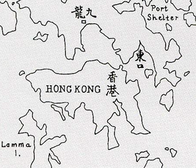
《維多利亞之東》是指今日的將軍澳。在1898年《展拓香港界址專條》的香港地圖中,將軍澳被標載為「東口」,意思可能是維多利亞港之東面出口。
《維多利亞之東》是一片消失的海。八十代港英政府把將軍澳開發成第三代新市鎮, 整個新市鎮的土地主要依靠開山填海得來。
在FUSE 藝術家駐留計劃,我以約一百年作為時間範圍 - 從1906年至2017年的城市發展脈絡裡, 以四個切入點 -山、水、海岸和風; 透過歷史研究及實地考察的方式, 在坦露於當下的人文風景的平淡影像裡,記錄、刻劃和重塑沉澱於歷史、政治、殖民統治和城市政策底下的空間軌跡。
“Victoria East” is approximately today’s Tseung Kwan O. On the map of “Hong Kong Extension” dated 1898, the location of Tseung Kwan O is marked as “East Opening/ East Exit”, probably denoting the eastern outlet of Victoria Harbour.
“Victoria East” is a vanished sea. When the British colonial government decided to develop Tseung Kwan O in 1980s as the third generation of “new town”, the land was entirely reclaimed from hills and the sea.
During FUSE artist residency, I set a time frame of a century, i.e. 1906-2017, to investigate urban development from four perspectives – mountain, sea, coastline and wind. Through archival research and field study, I am exposed to the unadorned imageries of culture and landscape at present. From there I record, carve and recreate the spatial traces in relation to history, politics, colonisation and urban planning.
(please click page 2, 3 to continue reading)